
Addressing environmental vulnerabilities with Artificial Intelligence
The challenge of missing data
The identification of environmental and social vulnerabilities is a major challenge today. It involves identifying communities and geographical areas exposed to significant risks, ranging from natural disasters to complex social dynamics. This includes events such as forest fires, floods, droughts and the presence of illegal settlements, which threaten the safety of people and the environment.
The ability to accurately identify these vulnerabilities is crucial for taking preventive and effective measures, as well as for strategic environmental and social planning. In this context, artificial intelligence and the analysis of satellite images emerge as fundamentally important tools.
AI offers extraordinary potential for facing these complex problems. Through machine learning algorithms, it is capable of rapidly analyzing huge amounts of data from different sources, including satellite images, allowing unprecedented accuracy in identifying vulnerabilities. However, there is one important detail that threatens to hinder our progress: the lack of complete and accessible data.
An environmental challenge: fire prediction
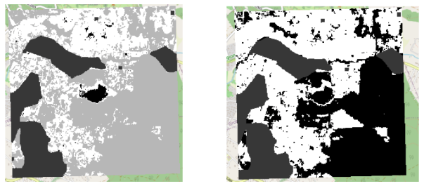
A tangible example of this challenge emerges in the area of fire forecasting. Looking at an image of a past fire and the predictions of an IA system such as Sevara, the Omninext Group’s Environmental Risk Assessment Service, it might seem that there is a huge discrepancy between the areas indicated as being at risk. But the real question to ask is: is this really a mistake? Or does it reflect the lack of accurate data on these events?
The collection of fire data is a complex task, often hidden behind systems that make the planned acquisition of crucial information difficult.
There is access to the image of a fire, but not information on the burnt area, the point of ignition or the cause of the fire. The lack of this data makes it difficult for those dealing with these problems to clearly define the context in which they operate.
AI is as intelligent as the human ability to mathematically define a problem, but this definition is constrained by the availability of data containing all the necessary information. Without this data, AI relies on incomplete information and can generate broad forecasts covering vast areas, as evidenced in fire forecast maps.
The lack of fire data leads to a number of challenges, from manual data collection to the use of additional algorithms to define the areas affected. All this introduces inaccuracies in problem definition and can lead to noise in the results.
Moreover, the absence of information on the point of ignition of a fire makes it difficult to distinguish between areas that were actually affected by a fire and those that had similar characteristics but were not affected. This limitation makes the identification of areas at risk complex.
Addressing this challenge requires coordinated efforts to collect detailed fire data, make it accessible and thus improve the accuracy of AI predictions. Only with complete data can the problem be clearly defined and the effectiveness of the algorithms assessed. This is a crucial step in addressing the environmental and social challenges that put communities at risk.
An urban challenge: unlisted buildings
The challenge of missing data, however, is not limited to fires. Another critical issue, in fact, is the identification of unlisted buildings.
This service, available on the Sevara platform, provides an estimate of buildings that are off the land register, using satellite images and public information from the Italian land register.
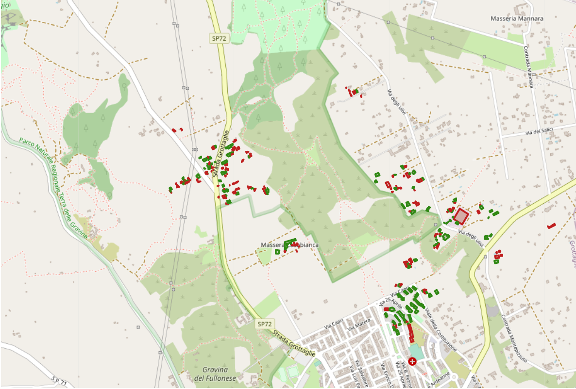
In the image, it is shown an area of Italy with in red all the buildings that do not result from the consultation of the land register database.
The main difficulty here is the lack of a structured list of buildings registered in the Italian land register to make an accurate comparison. The land register, in fact, provides information on the presence or absence of listed buildings, but does not allow a programmatic use of the data. This data structure, on the other hand, is essential for computer processing.
To solve a ‘state’ problem like this, the collaboration of all stakeholders is essential. However, the lack of access to structured data is a challenge that requires unconventional solutions, such as the cross-referencing of satellite images with Open Data available online.
In conclusion, addressing environmental and social vulnerabilities requires not only the use of artificial intelligence and satellite imagery, but also access to comprehensive and structured data. This is a crucial step in addressing challenges that endanger communities, as demonstrated by both the frequent forest fires in Italy and the fight against illegal buildings. Only with accurate data is it possible to clearly define the problem and assess the effectiveness of solutions.